
WEATHER: Drowning F-16’s
- Dr. Barry Lynn
- Jan 17, 2020
- 2 min read
![Illustration: Israeli Air Force F-16B in a Hardened Aircraft Shelter by Nehemia G - Hebrew Wikipedia [CC BY-SA 3.0] via Wikimedia](https://static.wixstatic.com/media/09570e_50a15d24b4a94196a8e5de3ba2faa901~mv2.jpg/v1/fill/w_980,h_551,al_c,q_85,usm_0.66_1.00_0.01,enc_avif,quality_auto/09570e_50a15d24b4a94196a8e5de3ba2faa901~mv2.jpg)
Illustration: Israeli Air Force F-16B in a Hardened Aircraft Shelter by Nehemia G - Hebrew Wikipedia [CC BY-SA 3.0] via Wikimedia
So much has happened weather wise and else wise in the world that I feel rather tuckered out. I suppose then that the recent spell of mild weather is a welcome relief (especially to those that are in the process of drying out).
Yet, after an unusually mild afternoon tomorrow, winter is poised to make a return. Low pressure will arrive from the southeast, and then receive an injection of colder air from the direction of Turkey as we move into Shabbat. After showers on Shabbat, Sunday into Tuesday morning looks to see more showers and periods of rain. Temperatures at upper levels will not be nearly as cold as within our last storm so we don't expect heavy thunderstorms.
After a short break, another storm should threaten us towards the end of next week. There is a chance of wet snow in Jerusalem and an accumulating snow in Gush Etzion. There is still plenty of cold air "locked" up over the polar regions as the AO and NAO remain positive and are forecast to remain positive for the foreseeable future. We might be able to tap into this cold air if a strong enough ridge builds into Western Europe. Time will tell, and we'll have to wait a few days to know if a chance will become something to more seriously talk about.
Time will also tell what will be the results of the investigation of the Air Force into recent flood related damages to F-16 fighter aircraft. As quoted, Israeli Air Force (IAF) commander Amikam Norkin “said the event was unbecoming of the [air] force and believed it was important to investigation, learn lessons and implement them in order to prevent similar events in the future."
The article claimed that the IAF was aware that rain was expected, and a number of aircraft had been moved to "higher ground," but these aircraft were not. Yet, information from our Total Lightning Network would have provided ample warning to the IAF to pay heed to the weather.
Storms first developed around 2:15 IST off the southeast coast,
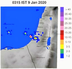
northwest of Ashkelon, arrived over land around 2:45 IST, and the lightning network indicated that storms then moved southeastward over land until 4:30 IST (an example is shown to the left). Severe flooding occurring in Ashdod was one result. Thirteen million gallons of water flooded the IAF base hanger between 5 and 5:30 in the morning.
Before proceeding too far to look for the reason why the planes were damaged and tens of millions of repairs needed, the investigators might simply ask why they don't use Total Lightning Data to monitor dangerous storms.

Dr. Lynn is a lecturer at The Hebrew University of Jerusalem, Earth Sciences Department. He is also CEO of Weather It Is, LTD, a company that specializes in reducing weather risk. Click here to read more of this writer’s work in The Jerusalem Herald.


Comments